Nestled in the heart of Arizona, the Prescott National Forest is not just a haven for nature enthusiasts but also a gold mine for geology aficionados. The trails of this forest reveal the Earth’s artistic palette, with unique geological features at every turn.

This guide will journey through these marvelous formations, making your next hike in the forest both enlightening and enchanting.
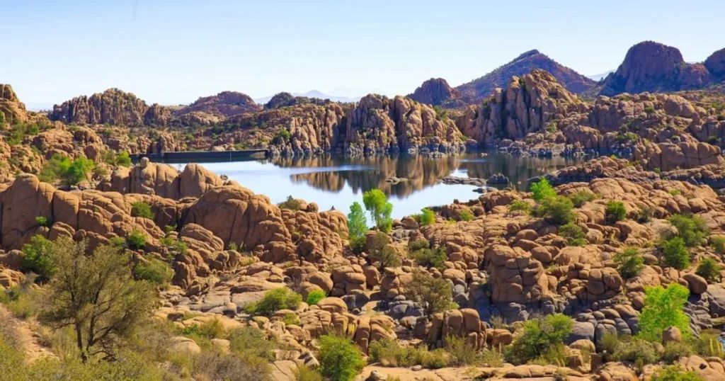
Granite Dells
The Granite Dells are nature’s sculpted masterpieces, etched by time and elements. These iconic rock formations, characterized by their rugged, weather-worn surfaces and distinctive rounded shapes, are primarily composed of granite – an intrusive igneous rock.
Over millions of years, erosion has chiseled away at the granite, giving rise to the Dells’ unique undulating profiles. Often juxtaposed against azure skies or nestled beside tranquil waters, these formations stand as timeless sentinels, bearing testament to the enduring power of geological processes.
For those fortunate enough to wander amidst or gaze upon the Granite Dells, it’s a journey through Earth’s art gallery, each rock face narrating tales of ancient magma, pressure, and erosive forces at play.
Formation and Age of the Granite Dells
Believed to be over 1.4 billion years old, the Granite Dells are among the oldest exposed rock formations on Earth.
Formed from cooled magma, these granitic rocks were later eroded by wind and water, resulting in the unique rounded appearance we observe today.
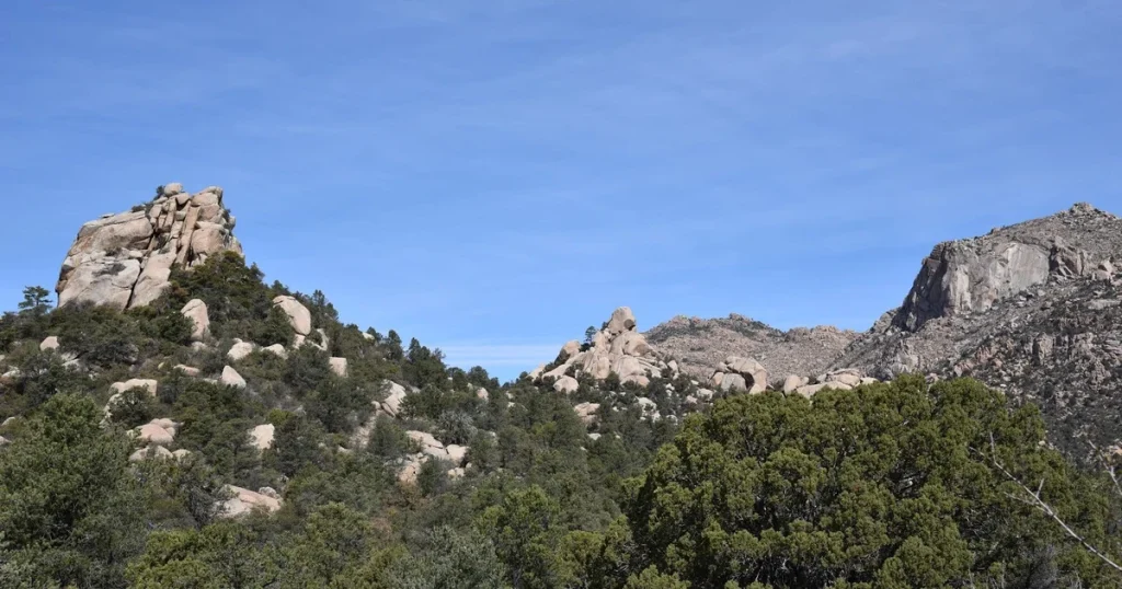
Popular Trails through the Dells
The Peavine and Iron King Trails offer breathtaking views of the Granite Dells. Winding through these ancient rocks, one can feel the weight of geological time.
The trails also provide spots where one can observe the Dells’ peculiar weathering patterns and joints. Peavine and Iron King Trail Map
Basaltic Lava Flows
Basaltic lava flows are the molten whispers of our planet’s fiery interior, seeping out from the depths and hardening upon contact with the cooler atmosphere. Characterized by their dark, fine-grained texture, these flows originate from volcanic eruptions, their low viscosity allowing them to spread out over vast areas and create expansive plains.
As they cool, they can form distinctive hexagonal column structures, a testament to the fascinating interplay of chemistry, temperature, and physics.
When one witnesses these ancient flows, like those that might be found in various parts of the world, they’re seeing pages from Earth’s tumultuous geologic diary, chronicling episodes of eruption, flow, and eventual solidification.
Origins and Significance of Basaltic Rock
Basalt is formed from the rapid cooling of lava rich in magnesium and iron. Geology.com states that these rocks can be found on almost all continents, a testament to Earth’s volcanic history.
In Prescott National Forest, the basaltic flows date back millions of years, showcasing various stages of erosion.
Trails That Showcase the Lava Flows
While many trails offer glimpses of these lava flows, the Lava River Trail stands out. Hikers can observe the intricacies of basaltic formations, including columnar joints that resemble organ pipes.
The trail, with its occasional basaltic outcrops, serves as a reminder of the dynamic forces that have shaped our planet.
Limestone Caves
Limestone caves are nature’s subterranean marvels, weaving a maze of mystery beneath the Earth’s crust. Formed through the slow dissolution of limestone by slightly acidic water, these caves showcase a realm of stalactites, stalagmites, and other intricate formations that appear almost sculpted by an artist’s hand.
The silent chambers and echoing corridors of these caves, like those found in parts of the Prescott National Forest, have been shaped over millennia, bearing witness to the slow dance of water and rock. Each twist and turn within these darkened depths reveals a story of geology, time, and the relentless persistence of nature’s forces.
How Limestone Caves are Formed in Prescott National Forest
Limestone, a sedimentary rock primarily composed of calcium carbonate, is susceptible to dissolution when it comes into contact with mildly acidic rainwater.
Over millennia, this process can lead to the formation of vast underground cave systems. National Geographic has an informative article on the fascinating process behind these formations.
Exploring the Underground: Trail Recommendations:
The Cave Springs Trail is a treasure trove for those interested in geology. While the trail itself does not venture deep into caves, it provides access points and vantage spots to appreciate these geological wonders.
Besides, certain sections of the trail exhibit karst topography, characteristic of landscapes underlain by limestone.
Ancient Volcanic Calderas
Once centers of fiery upheaval, ancient volcanic calderas stand as monumental reminders of the Earth’s dynamic inner forces. These vast depressions, formed by the colossal collapse of a volcano’s magma chamber, bear scars of explosive past eruptions.
Over time, many calderas have evolved, with erosion softening their contours, and forests or lakes taking residence within their bounds. Their presence in landscapes like the Prescott National Forest offers a stark juxtaposition: a once volatile furnace of molten rock now transformed into a sanctuary of tranquil beauty and biodiversity.
Understanding Volcanic Calderas and Their Formation
Calderas are formed when a volcano erupts so violently that it collapses into the emptied magma chamber beneath it. The US Geological Survey provides an in-depth look into this phenomenon. In Prescott, these calderas serve as a window into the region’s tumultuous geological history.
The Caldera Basin Trail is the best route to experience these ancient volcanic features. With viewpoints overlooking the collapsed terrains and interpretative signs detailing the area’s volcanic history, it’s both an educational and visually stunning hike.
Goldwater Lake and Its Origins
Goldwater Lake, a serene gem nestled within the Prescott National Forest, is a testament to nature’s artistry and geological processes. Originating from the damming of Bannon Creek, its tranquil waters now reflect the surrounding Ponderosa Pines and granite outcroppings.
The lake’s basin, shaped over millennia by erosion and sedimentary deposition, provides a haven for both wildlife and outdoor enthusiasts alike. Today, as visitors paddle across its shimmering surface or stroll along its shores, they’re treading upon a rich tapestry of geological and human history intertwined.
The Geology Behind Goldwater Lake Formation
The lake’s basin is a result of tectonic activities coupled with erosional forces. Over time, water accumulated in this depression, leading to the formation of the lake. Sites like Earth Science World provide comprehensive insights into such natural processes.
The Goldwater Lake Loop is a scenic trail skirting the lake’s perimeter. As you walk, you’ll notice the different rock layers exposed around the lake, each telling a different chapter of the region’s geological story
The Rolling Topography of Chaparral Habitats
The chaparral habitat, with its undulating terrains and shrubby vegetation, is another fascinating feature of Prescott National Forest.
Chaparrals, often found on the slopes of mountain ranges, are shaped by a combination of tectonic uplift and erosion. The unique soil composition and drainage patterns also play a role in supporting the characteristic flora of this biome.
Best Trails to Experience Chaparral Sceneries
Chaparral Ridge Trail offers an immersive experience. The trail showcases:
- The distinctive terrains
- Evidence of past erosional patterns
- The resilient flora adapted to this landscape
A hike here is not just a journey through a unique biome but also a walk through geological time.
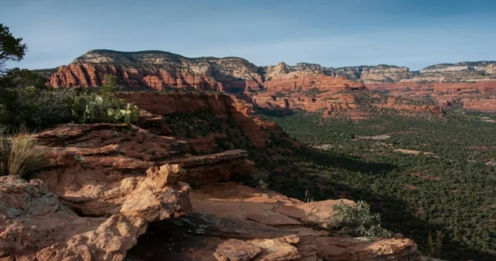
Sedimentary Rock Formations
Sedimentary rock formations tell tales of Earth’s history in layered chronicles. Born from accumulated sediments like sand, silt, and organic material, these formations often showcase beautiful stratification, revealing eons of deposition in their bands.
Over time, pressure and minimal heat transform these accumulations into solid rock, preserving fossils and offering clues about past environments. From the vibrant cliffs of canyons to the gentle slopes of ancient seabeds, sedimentary rocks serve as a window into epochs gone by, each layer recounting a chapter of the Earth’s ever-evolving narrative.
Layers of Time: Understanding Sedimentary Rock Types
Sedimentary rocks are formed from accumulated mineral and organic particles. Over time, these layers compact and harden, preserving a record of past environments. A detailed guide to these formations can be found at The Geological Society.
The Layered Legacy Trail offers hikers a chance to observe these rock formations closely. Distinct strata and fossil imprints can be spotted along the trail, each a clue to the region’s past ecosystems and climates.
The Peculiarities of Ponderosa Pine Forest Soils
The soils beneath the towering Ponderosa Pines are as intriguing as the trees themselves. Often springing from a mix of volcanic ash and decayed organic matter, these soils exhibit a unique acidic profile, which aids the decomposition of fallen pine needles and other forest detritus.
This symbiotic relationship between the soil and the pine ensures the forest floor is rich and continually rejuvenated, creating a foundation that sustains not just the majestic Ponderosa Pines but also a myriad of forest life that calls this habitat home.
The Geology That Supports Ponderosa Pines
Ponderosa Pine forests prefer well-drained soils, often originating from volcanic ash and decayed organic matter. These soils are acidic, facilitating the decomposition of pine needles and other organic debris. The Soil Science Society of America provides an enriching understanding of this intricate relationship between geology and biology.
For those keen on understanding this synergy, the Pine Shadow Trail offers an exemplary route. Not only does it pass through dense Ponderosa Pine forests, but periodic signboards and exposed soil patches allow hikers to observe the unique soil characteristics supporting these majestic trees.
Mesas and Plateaus
Mesas and plateaus are nature’s elevated canvases, standing prominently amid landscapes and offering vast, panoramic views of the surrounding terrain. Formed over eons, these flat-topped wonders are a result of differential erosion, where layers of harder rock resist erosion while the softer layers below wear away.
They serve as silent witnesses to the relentless dance of wind, water, and time, embodying the majesty and persistence of Earth’s geological processes. Whether one is looking upon a sprawling plateau or a solitary mesa, it’s a glimpse into the dynamic forces that have sculpted our planet’s face.
Understanding the Formation of Mesas and Plateaus
Mesas and plateaus are formed due to differential erosion. While the harder rock layers resist erosion and stay intact, softer layers beneath get eroded over time. Over millions of years, this process has resulted in these flat-topped wonders. For a deeper dive into this topic, Britannica provides a comprehensive breakdown.
Mesa Vista Trail is the perfect pathway to traverse these elevated terrains. As the trail zigzags across the landscape, it offers glimpses of the layered rock formations and the expansive vistas from atop the mesas. It’s a journey that marries elevation with education.
FAQs: Unique Geological features along trails in Prescott National Forest
How were the geological features in Prescott National Forest formed?
Many of the features resulted from various processes such as erosion, volcanic activity, and sediment deposition. Each feature, be it the Granite Dells or the limestone caves, has a unique origin story spanning millions of years.
Are there any active geological processes in the forest?
Yes, erosion, sediment deposition, and minor seismic activities continue to reshape the forest, though on a scale that might not be immediately noticeable in our lifetimes.In this section, we will be delving into some of the most common inquiries and curiosities that surround our topic.
Which trail is the best for a comprehensive geological experience?
While each trail offers a unique perspective, combining trails like Granite Dells with the Canyon Whisperer Trail provides a well-rounded geological experience.
What precautions should visitors take while exploring the geological features?
Always stick to marked trails, wear appropriate footwear, stay hydrated, and respect the forest’s rules and guidelines to ensure safety.
How are these geological wonders being conserved?
Prescott National Forest has a range of conservation programs in place, aided by research and input from organizations like the US Geological Survey. These efforts are geared towards preserving these wonders for future generations.
Conclusion:
Our journey through the Prescott National Forest’s geological wonders comes to an end, but the stories these rocks tell are timeless. From ancient lava flows to the serenity of Goldwater Lake, each feature unravels a chapter of Earth’s intricate tapestry.
The next time you lace up your hiking boots and tread these trails, remember, that you’re not just walking on land; you’re traversing the pages of our planet’s grand saga.


Leave a Comment
You must be logged in to post a comment.